


Karibu Kilifi County
")
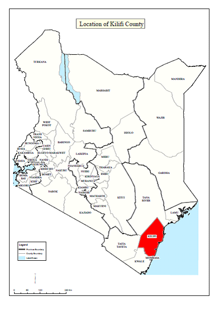
Kilifi County covers a total surface area of 12,610 km2 and accounts for 2.17 per cent of Kenya’s total surface area. It borders the counties of Tana River to the North, Taita Taveta to the West, Mombasa and Kwale to the South and the Indian Ocean to the East.
More than half of the land in Kilifi is arable, however only 31% of the farmers hold titles to their land. Maize and cassava are the main subsistence crops grown in the County. The main cash crops grown in the county include coconuts, cashew nuts, sisal and citrus fruits such as mangoes and pineapples.
Although many health facilities exist within the county, these are unevenly distributed and mainly located along major roads. The lack of permanent health workers operating within the communities reduces efficiency levels in the delivery of medical services. The major health facilities in the county are as follows:
number, 51% are men while 49% are women. There are 418 primary and 86 secondary schools catering for an estimated 256,000 and 22,500 students respectively. There are 13 youth polytechnics, one college and a University campus.
VISION
To be a leading, vibrant, highly productive, secure and prosperous county providing a high quality of life for all its inhabitants.
MISSION
The county will provide the environment for efficient utilization of resources, effective provision of essential services, and industrial growth and development initiatives for improved quality of life for all.
CORE VALUES
- Honesty, Integrity and prudent use of pub lic resources Team work and appreciation for diversity Environmental Sustainability
- Good Governance, Transparency and accountability
- Equity, inclusive people-driven leadership
- Use of ICT and Innovation
- Hardworking
- Harmonious & Peaceful coexistence
The average annual rainfall ranges from 300mm in the hinterland to 1,300mm at the coastal belt. The coastal belt receives an average annual rainfall of about 900mm to 1,100mm with marked decrease in intensity to the hinterland. Areas with highest rainfall include Mtwapa and to the north of the coastal strip around the Arabuko Sokoke Forest. Evaporation ranges from 1800mm along the coastal strip to 2200mm in the Nyika plateau in the interior. The highest evaporation rate is experienced during the months of January to March in all parts of the county.
The annual temperatures in the county range between 21 oC and 30oC in the coastal belt and between 30oC and 34oC in the hinterland. The county experiences relatively low wind speeds ranging between 4.8 km/hr and 12 Km/hr.
The county can be divided into five Agro- Ecological Zones (AEZ), which define areas that have similar characteristics such as annual mean temperatures, vegetation and humidity.
Coconut-Cassava Zone: This zone has the highest potential for crop production in the county spreading along the coastal uplands and low-level coastal plains. Major farming activities include tree cropping (mango, citrus, cashew nuts, and coconuts), vegetables (chilli, brinjals, okra etc.), food crops (maize, bananas, cowpeas, green grams etc.) and upland rice. Dairy farming also does well in this zone. It has an average precipitation of 1,300mm per annum and mean annual temperature of 24 0C.
Lowland Ranching: It varies in altitude of 90-300m with mean annual temperature of 270 C and annual precipitation of 350-700mm. Major activities within this zone include ranching and wildlife.
Coconut Cashew nut-Cassava Zone: This zone is mainly found in Kilifi South and North Constituencies and is the smallest of all the zones. It varies in altitude from 30-310m above sea level with mean temperature of 270 C and annual precipitation of 900mm per annum.
The area has potential for those crops grown in the coconut-cassava zones and cashew nut- cassava zones.
Departmental Goals, Objectives And Strategies
The goals, objectives and strategies of the department are given in the table as follows:
Kilifi County is one of the six counties in coast region. The county lies between latitude 2o20o and 4o0o South, and between longitude 39o 05o and 40o 14o East. It borders Kwale County tothe south west, Taita Taveta County to the west, Tana River County to the north, Mombasa County to the south and Indian Ocean to the east.
The county covers an area of 12,609.7 km2.